It is fitting that we call the site of a building its footprint, since its impression provides us with tracks that we may follow into the past. If we could travel back in time 750 years, we would find a riotous gathering raising their tents south of a grand house built by King Henry III’s brother, Richard, Earl of Cornwall, on the Manor of Isleworth (later, Twickenham Park). We would be surrounded by open fields, with common meadows running along the west bank of the Thames.
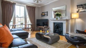
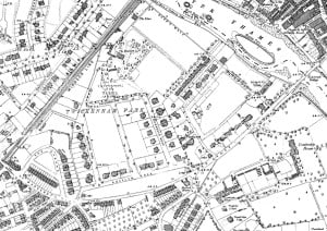 To the south-west rises the Medieval village of Twickenham (around Church Street) on the higher ground beside the Twickenham Ait (Eel Pie Island), its buildings clustered around a church of Kentish rag stone (St Mary’s). There are water-mills, weirs and fisheries along the river, orchards and open farmland parched by drought. On 29 June 1263, the Manor of Isleworth played host to the historic Gathering of the Barons, where Simon de Montfort’s rebellious noblemen held a conference with the King that sowed the seeds for England’s first true Parliament. When one discovers historic maps the footprints become clearer, excitingly so. Shown here are two maps that were drawn in the nineteenth century but allow us to take our first steps much further back in time. The first, from 1879, is clearly marked with the Encampment of the Barons at the top of Twickenham Park. The second, from 1896, shows the development of the A-shaped crescent and houses of The Barons in the south-west corner. Viewing the same area on Googlemaps reveals how early development shaped the topography of the quarter-circle we see today bordered by the railway, the river and St Margarets Road. We can locate the luxury apartments at 20 The Barons, and begin to picture our place both in time and space: discovering how our own footprints rest solidly within those of our ancestors.
(For more information, and map source, see the excellent Twickenham Park Resident Association)